
{{product.productLabel}} {{product.model}}
{{#if product.featureValues}}{{product.productPrice.formattedPrice}} {{#if product.productPrice.priceType === "PRICE_RANGE" }} - {{product.productPrice.formattedPriceMax}} {{/if}}
{{#each product.specData:i}}
{{name}}: {{value}}
{{#i!=(product.specData.length-1)}}
{{/end}}
{{/each}}
{{{product.idpText}}}

... comprehensive industry-standard data import and export formats allow LandStar 8 to be seamlessly integrated into existing software environments and ensure instant productivity.

... reference makes it easy to locate boundary stones. An existing survey can be checked for accuracy, and the location of land parcels can be verified. It is also easy to measure markers such as shaft covers ...
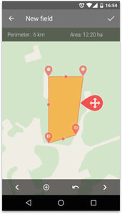
Create and manage field boundaries. Use GPS tracking to calculate the covered area automatically. Manually add the quantity of material used for the performed operation. - Maps Create and manage field boundaries. Store information ...
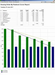
... computer software package designed specifically to complement the Jenquip Rising Plate Pasture Meters. Straightforward to understand and use, without the confusing ‘bells and whistles’ of some feed budgeting programs, ...
Please specify:
Help us improve:
remaining