
{{product.productLabel}} {{product.model}}
{{#if product.featureValues}}{{product.productPrice.formattedPrice}} {{#if product.productPrice.priceType === "PRICE_RANGE" }} - {{product.productPrice.formattedPriceMax}} {{/if}}
{{#each product.specData:i}}
{{name}}: {{value}}
{{#i!=(product.specData.length-1)}}
{{/end}}
{{/each}}
{{{product.idpText}}}

... multispectral, thermal or LiDAR. What does it measure? THERMAL IMAGES (Temperature maps, High resolution, Forestry, Agricultural (WATER STRESS)) MULTIESPECTRALES (Crop health, Nutritional status, Irrigation problems, Fungi, Insects ...
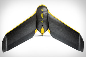
... Use this fully autonomous drone to capture high-resolution aerial photos that you can transform into accurate orthomosaics & 3D models. The eBee can cover up to 12 km2 (4.6 mi2) in a single automated flight, while flights over smaller ...
senseFly

... system featuring RTK/PPK upgradeability for survey-grade accuracy on demand. The eBee Plus can map more square kilometres per flight, than any drone in its weight class, allowing you to maximise your efficiency and ...
senseFly

... From drone to action: capture actionable crop data across four multispectral bands, plus RGB imagery, spanning hundreds of acres in a single flight. The eBee SQ‘s precise, calibrated multispectral imagery provides reliable insights ...
senseFly
the best suppliers