
- Farm Management
- Precision agriculture
- GNSS receiver
- Shanghai eSurvey GNSS Co., Ltd.
GNSS receiver eRTK304GGLONASSGPS


Add to favorites
Compare this product
Characteristics
- Network
- GNSS, GPS, GLONASS, GALILEO, 4G
- Other characteristics
- precision agriculture, IP67
Description
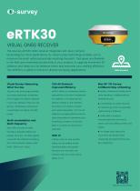
VISUAL GNSS RECEIVER WITH DUAL-CAMERA TECHNOLOGY
The eSurvey eRTK30 GNSS receiver integrates with dual-camera technology for more applications. Its visual survey technology enables you to measure the point without physically reaching the point. That gives you flexibility in the field and maximises productivity in your projects. It supports immersive 3D stakeout and helps you do stakeout faster and improves your working efficiency. The eRTK30 is a perfect choice for diverse surveying applications.
- Visual Survey: Measuring What You See
Visual survey technology provides accurate positioning coordinates from images and videos captured in seconds. Measure what you see, get the coordinates of previously unreachable and signal-blocked points.
- CAD AR Stakeout: Improved Efficiency
eRTK30 offers an immersive, intuitive perspective of the site to implement the stakeout. CAD drawings are directly marked on the interface, thus there is no need to choose each point individually. The CAD AR stakeout is a highly effective tool for optimizing stakeout operations and simplifying complex construction tasks in a variety of construction scenarios.
- Multi-Constellation and Multi-Frequency
With 1408 channels of GNSS tracking, it provides stable and reliable accuracy. All GNSS signals come with the standard including GPS, BDS, GLONASS, Galileo, QZSS, NavIC, SBAS and L-Band.
- Web UI
It allows users to view position status, set up working mode, download data, and update firmware from the Web user interface with any smart phone, tablet, or PC.
- Max 60° Tilt Survey: A Different Way of Working
- Quickly measure accurate points while standing or walking without leveling the pole.
- Concentrate on where the pole tip needs to go, which is especially useful during a stakeout.
- Easily start a survey in environments that are hard to reach, such as building corners and slopes.
- No longer worry about the movement of the pole when measuring, provided that the pole tip is stationary.
Technical Specifications / Features
- Product: eRTK30
- Type: Visual GNSS Receiver with Dual-Camera Technology
- Visual survey technology for non-contact point measurement
- Immersive 3D stakeout with AR and CAD drawing overlay
- 1408 GNSS tracking channels
- Supports GPS, BDS, GLONASS, Galileo, QZSS, NavIC, SBAS, L-Band
- Web UI for configuration and data management
- Max 60° tilt survey capability
- Designed for diverse surveying applications
VIDEO
Catalogs
eRTK30
2 Pages

Product Catalog
50 Pages
Other Shanghai eSurvey GNSS Co., Ltd. products
Integrated GNSS Systems


Related Searches
- GNSS receiver
- Digital control unit
- Guidance system
- GPS receiver
- GLONASS receiver
- GALILEO receiver
- RTK receiver
- Automated guidance system
- Precision agriculture receiver
- Farm machinery antenna
- Tractor guidance system
- GNSS guidance system
- Agriculture machine guidance system
- Wireless receiver
- GNSS antenna
- RTK guidance system
- GPS guidance system
- 4G receiver
- Satellite receiver
- Bluetooth receiver
*Prices are pre-tax. They exclude delivery charges and customs duties and do not include additional charges for installation or activation options. Prices are indicative only and may vary by country, with changes to the cost of raw materials and exchange rates.